National parks offer unparalleled opportunities to immerse yourself in nature’s grandeur, providing awe-inspiring landscapes and diverse ecosystems for hiking enthusiasts and outdoor adventurers. From geothermal wonders to towering granite monoliths, these protected areas showcase Earth’s most spectacular natural phenomena. Whether you’re an experienced trekker or a casual nature lover, exploring these pristine wilderness areas promises unforgettable experiences and a deeper connection with our planet’s geological and ecological marvels.
Yellowstone: geothermal wonders and wildlife ecosystems
Yellowstone National Park, established in 1872, stands as a testament to the raw power of Earth’s geological processes. This vast wilderness, spanning nearly 9,000 square kilometres, offers visitors a glimpse into a world shaped by volcanic activity and teeming with diverse wildlife.
Old faithful geyser: hydrothermal mechanics and eruption patterns
Old Faithful, Yellowstone’s most famous attraction, exemplifies the park’s geothermal activity. This iconic geyser erupts approximately every 90 minutes, showcasing the intricate interplay between underground heat, water, and pressure. The predictability of Old Faithful’s eruptions stems from its unique plumbing system, where superheated water accumulates in a chamber until pressure forces it upward, resulting in a spectacular display reaching heights of up to 56 metres.
Visitors can witness this natural phenomenon from various vantage points, including the Old Faithful Inn, a historic lodge that offers a prime viewing location. For those interested in the science behind the eruptions, the Old Faithful Visitor Education Center provides in-depth information on the park’s hydrothermal features and their geological significance.
Grand prismatic spring: thermophilic bacteria and chromatic phenomena
The Grand Prismatic Spring, Yellowstone’s largest hot spring, presents a mesmerising display of vivid colours. This natural wonder owes its striking appearance to thermophilic bacteria that thrive in extreme temperatures. The spring’s rainbow-like hues result from different species of microorganisms adapting to varying water temperatures across the spring’s expanse.
To fully appreciate the Grand Prismatic Spring’s beauty, hikers can take the Fairy Falls Trail to an overlook that provides a breathtaking aerial view. This vantage point allows you to observe the spring’s concentric rings of colour, from the deep blue centre to the vibrant orange edges, set against the backdrop of Yellowstone’s rugged landscape.
Lamar valley: wolf reintroduction and trophic cascades
Lamar Valley, often referred to as America’s Serengeti, offers unparalleled wildlife viewing opportunities. This expansive grassland plays a crucial role in Yellowstone’s ecosystem, particularly since the reintroduction of wolves in 1995. This conservation effort has led to a remarkable trophic cascade , where the presence of wolves has influenced the behaviour of other species, ultimately reshaping the valley’s entire ecosystem.
Early morning or late evening visits to Lamar Valley provide the best chances to observe wolves, bison, elk, and grizzly bears in their natural habitat. Bring binoculars or a spotting scope to enhance your wildlife watching experience, and consider joining a guided tour led by park naturalists for expert insights into the valley’s ecological dynamics.
Mammoth hot springs: travertine terrace formation process
Mammoth Hot Springs showcases the ongoing geological processes that shape Yellowstone’s landscape. These terraced hot springs form as hot water rich in dissolved limestone (calcium carbonate) rises through cracks in the Earth’s crust. As the water cools and releases carbon dioxide, it deposits minerals, creating the distinctive stepped travertine formations.
Visitors can explore the Upper and Lower Terraces via a network of boardwalks, offering close-up views of active and dormant spring features. The ever-changing nature of Mammoth Hot Springs means that each visit can reveal new formations and shifting patterns in the mineral deposits, making it a dynamic and captivating area of the park to explore repeatedly.
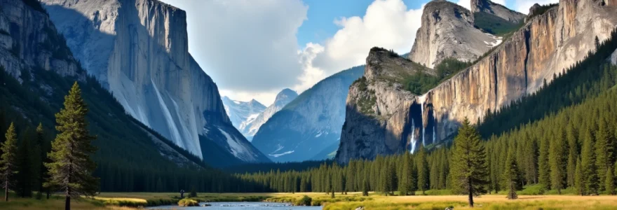
Yosemite: glacial geology and vertical wilderness
Yosemite National Park, renowned for its towering granite cliffs and cascading waterfalls, stands as a testament to the power of glacial sculpting. This California gem attracts millions of visitors annually, drawn by its dramatic landscapes and diverse ecosystems.
Half dome: granite exfoliation and recreational climbing routes
Half Dome, Yosemite’s iconic granite monolith, rises nearly 1,500 metres above the valley floor. This massive formation exemplifies the process of exfoliation , where layers of rock peel away due to pressure release, creating its distinctive rounded shape. The exposed granite face of Half Dome presents a formidable challenge for rock climbers, with routes ranging from moderate to extremely difficult.
For hikers, the ascent to Half Dome’s summit via the Cable Route offers an exhilarating adventure. This 14-16 mile round trip requires a permit and involves a steep climb up the dome’s eastern face, assisted by cables. The panoramic views from the summit are unparalleled, offering a 360-degree perspective of Yosemite Valley and the surrounding Sierra Nevada mountains.
Yosemite falls: snowmelt hydrology and waterfall mechanics
Yosemite Falls, one of North America’s tallest waterfalls, showcases the park’s dramatic hydrology. Comprising three sections – Upper Yosemite Fall, the middle cascades, and Lower Yosemite Fall – this 739-metre waterfall is fed primarily by snowmelt from the Sierra Nevada’s winter accumulation.
The falls’ flow varies significantly throughout the year, peaking in late spring and early summer as temperatures rise and snow melts rapidly. Visitors can experience the falls’ power up close via the Yosemite Falls Trail, a strenuous hike that ascends to the top of Upper Yosemite Fall. For a less demanding option, the Lower Yosemite Fall Trail offers an easy loop with excellent views of the entire waterfall.
Mariposa grove: giant sequoia ecology and fire adaptation
Mariposa Grove, home to over 500 mature giant sequoias, showcases some of the oldest and largest living organisms on Earth. These towering trees, some exceeding 3,000 years in age, demonstrate remarkable adaptations to their environment, including fire-resistant bark and the ability to regenerate from basal sprouts.
The grove’s ecology is intricately linked to periodic wildfires, which play a crucial role in sequoia reproduction by clearing the forest floor and releasing seeds from cones. Visitors can explore the grove via several hiking trails, including the Grizzly Giant Loop Trail, which passes by some of the most impressive specimens, such as the Grizzly Giant and the California Tunnel Tree.
Giant sequoias are not only awe-inspiring in their size and longevity but also serve as living chronicles of Earth’s climate history, with their growth rings providing valuable data on past environmental conditions.
Grand canyon: stratigraphy and colorado river dynamics
The Grand Canyon, carved by the Colorado River over millions of years, offers an unparalleled window into Earth’s geological history. This vast chasm, stretching 446 kilometres long and up to 29 kilometres wide, reveals a complex story of rock formation, erosion, and changing environments.
Vishnu schist: proterozoic rock formation analysis
At the bottom of the Grand Canyon lies the Vishnu Schist, some of the oldest exposed rock in North America. Dating back nearly two billion years to the Proterozoic Eon, these metamorphic rocks provide crucial insights into Earth’s early crustal development. The Vishnu Schist’s dark, folded layers bear witness to intense heat and pressure, offering geologists a rare glimpse into the planet’s ancient tectonic processes.
Hikers descending into the canyon can observe the Vishnu Schist along the Bright Angel and South Kaibab trails. The stark contrast between these ancient, dark rocks and the younger, lighter sedimentary layers above creates a striking visual journey through geological time.
Bright angel trail: geological time travel through rock layers
The Bright Angel Trail, one of the Grand Canyon’s most popular hiking routes, offers a unique opportunity to traverse nearly two billion years of Earth’s history. As you descend from the South Rim, each step takes you further back in time, passing through distinct rock layers that represent different geological eras.
The trail begins in the youngest rocks, the Kaibab Limestone, formed about 270 million years ago when the area was covered by a shallow sea. As you descend, you’ll pass through layers of sandstone, shale, and limestone, each telling a story of ancient environments – from windswept deserts to tropical seas. The journey culminates at the Colorado River, where the trail meets the ancient Vishnu Schist, completing a remarkable geological odyssey.
Havasu falls: travertine dam creation in havasupai territory
Havasu Falls, located within the Havasupai Indian Reservation, showcases the Grand Canyon’s dynamic hydrological processes. The falls’ striking blue-green water owes its colour to high concentrations of calcium carbonate, which also contributes to the formation of travertine dams and pools.
These travertine formations are constantly evolving, with new dams forming and old ones eroding away. The interaction between water, minerals, and gravity creates a ever-changing landscape of cascades and pools. Visiting Havasu Falls requires a permit and a challenging 10-mile hike, but the reward is access to one of the most picturesque and geologically interesting areas of the Grand Canyon.
Zion: sandstone cliffs and slot canyon exploration
Zion National Park, characterised by its towering sandstone cliffs and narrow canyons, offers a unique perspective on the power of water erosion in shaping landscapes. This Utah wonder presents visitors with a diverse array of geological features and hiking opportunities.
The narrows: flash flood risk assessment and river wading techniques
The Narrows, Zion’s most famous slot canyon, provides an immersive hiking experience through the Virgin River. This 16-mile journey takes you between towering sandstone walls that narrow to just 6 metres wide in some sections. Hiking The Narrows requires careful planning and awareness of flash flood risks, as sudden rainstorms can lead to dangerous water level increases.
When exploring The Narrows, proper river wading techniques are essential. Use a hiking stick for balance and wear appropriate footwear with good traction. It’s crucial to check weather forecasts and consult with park rangers about current conditions before embarking on this adventure. The Narrows offers a unique perspective on the canyon’s geology, allowing you to observe the intricate patterns carved by water into the sandstone over millennia.
Angels landing: High-Altitude trail engineering and safety measures
Angels Landing, one of Zion’s most thrilling hikes, culminates in a narrow fin of rock with precipitous drops on both sides. This 5.4-mile round trip hike ascends 1,488 feet, offering panoramic views of Zion Canyon. The final section of the trail features chains bolted into the rock to assist hikers along narrow ledges.
The engineering of Angels Landing trail is a testament to early 20th-century National Park Service efforts to make challenging terrain accessible. Safety measures, including the chain assists and strategically placed steps cut into the rock, allow hikers to navigate the most exposed sections. Despite these aids, the hike remains strenuous and requires a good level of fitness and comfort with heights.
The Angels Landing trail exemplifies the delicate balance between providing access to spectacular natural features and ensuring visitor safety in challenging terrain.
Kolob canyons: Lesser-Known geological formations and scenic drives
The Kolob Canyons section of Zion National Park offers a quieter, less-visited alternative to the main canyon. This area features a series of finger-like canyons carved into the western edge of the Colorado Plateau, showcasing stunning red rock formations and diverse plant life.
The Kolob Canyons Road, a 5-mile scenic drive, provides access to several viewpoints and trailheads. Hikes in this area, such as the Timber Creek Overlook Trail and the more challenging Taylor Creek Trail, offer opportunities to explore unique geological features like the Double Arch Alcove, a massive natural amphitheatre carved into the sandstone cliff face.
Glacier: alpine ecology and climate change indicators
Glacier National Park, straddling the U.S.-Canada border in Montana, is a pristine wilderness of rugged mountains, alpine meadows, and, as its name suggests, glacial features. This park serves as a living laboratory for studying the effects of climate change on alpine ecosystems.
Going-to-the-sun road: engineering marvel and snowplowing challenges
The Going-to-the-Sun Road, a 50-mile scenic route bisecting Glacier National Park, is considered an engineering feat. Completed in 1932, this road navigates steep mountain terrain, offering visitors breathtaking views of the park’s glacial landscape. The road’s construction required innovative solutions to overcome the challenges posed by the park’s rugged topography and extreme weather conditions.
Maintaining the Going-to-the-Sun Road presents ongoing challenges, particularly in terms of snow removal. Each spring, park crews undertake the monumental task of clearing the road, which can be buried under more than 80 feet of snow in some areas. This process, which can take up to 10 weeks, involves specialised equipment and careful planning to protect the road’s historic features and the surrounding environment.
Grinnell glacier: retreating ice fields and glacial lake formation
Grinnell Glacier, one of the park’s most accessible glaciers, offers a stark visual representation of climate change impacts. Since 1966, this glacier has lost 45% of its area, retreating significantly and leaving behind newly exposed rock and expanding glacial lakes.
The hike to Grinnell Glacier provides visitors with a unique opportunity to witness these changes firsthand. As you ascend the trail, you’ll pass by a series of glacial lakes, each marking a different stage in the glacier’s retreat. The Upper Grinnell Lake, formed by meltwater from the shrinking glacier, has expanded dramatically in recent decades, offering a clear indicator of the glacier’s rapid decline.
Hidden lake: alpine meadow biodiversity and mountain goat habitat
The Hidden Lake area, accessible from Logan Pass, showcases Glacier National Park’s rich alpine meadow ecosystems. These high-altitude environments, characterised by their short growing seasons and harsh conditions, support a diverse array of plant and animal species adapted to life in extreme environments.
The Hidden Lake Overlook Trail winds through subalpine meadows bursting with wildflowers during the brief summer season. This area is also prime habitat for mountain goats, often seen traversing the steep cliffs surrounding Hidden Lake. The fragile nature of this ecosystem underscores the importance of staying on designated trails to protect sensitive vegetation and wildlife habitats.
Alpine meadows, like those found at Hidden Lake, serve as early warning systems for climate change, with shifts in plant communities and animal behaviours providing valuable data on environmental changes.
Exploring these national parks offers not only breathtaking natural beauty but also profound insights into Earth’s geological processes, ecological dynamics, and the ongoing impacts of climate change. Whether you’re witnessing the geothermal wonders of Yellowstone, scaling the granite monoliths of Yosemite, descending into the depths of the Grand Canyon, navigating the narrow canyons of Zion, or observing the retreating glaciers of Glacier National Park, each experience provides a unique perspective on our planet’s natural history and its ongoing evolution.